
Thank you for supporting this site ❤️
Make a donation
Make a donation
Rechenberg topographic map
Click on the map to display elevation.
Thank you for supporting this site ❤️
Make a donation
Make a donation
Rechenberg
Der Rechenberg liegt im Nordosten Nürnbergs im Stadtteil St. Jobst, nördlich der Äußeren Sulzbacher Straße. Er erstreckt sich in Ost-West-Richtung und hat eine Größe von 5,6 ha. Seinen Mittelpunkt bildet der namensgebende „Rechenberg“, ein Höhenrücken aus Burgsandstein (ca. 338 m ü. NHN). Er ist die zweithöchste Erhebung im Stadtgebiet von Nürnberg.
Thank you for supporting this site ❤️
Make a donation
Make a donation
About this map
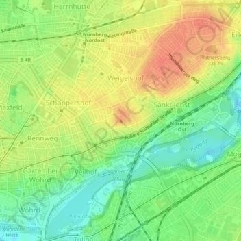
Name: Rechenberg topographic map, elevation, terrain.
Location: Rechenberg, Nürnberg, Bayern, 90491, Deutschland (49.46346 11.11061 49.46356 11.11071)
Average elevation: 319 m
Minimum elevation: 295 m
Maximum elevation: 343 m
Thank you for supporting this site ❤️
Make a donation
Make a donation
Other topographic maps
Click on a map to view its topography, its elevation and its terrain.
Thank you for supporting this site ❤️
Make a donation
Make a donation
Thank you for supporting this site ❤️
Make a donation
Make a donation
Thank you for supporting this site ❤️
Make a donation
Make a donation