
Mills River topographic map
Interactive map
Click on the map to display elevation.
About this map
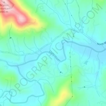
Name: Mills River topographic map, elevation, terrain.
Location: Mills River, Henderson County, North Carolina, United States (35.39246 -82.60987 35.39908 -82.58638)
Average elevation: 686 m
Minimum elevation: 636 m
Maximum elevation: 877 m
Other topographic maps
Click on a map to view its topography, its elevation and its terrain.
Mills River
United States > North Carolina > Henderson County > Mills River > Oak Hill Court
Mills River, Oak Hill Court, Mills River, Henderson County, North Carolina, 28759, United States
Average elevation: 633 m
Mills River
United States > North Carolina > Henderson County > Mills River > Oak Hill Court
Mills River, Oak Hill Court, Mills River, Henderson County, North Carolina, 28759, United States
Average elevation: 644 m