Geolocate

桃川镇 topographic map

Interactive map

Click on the map to display elevation.

About this map

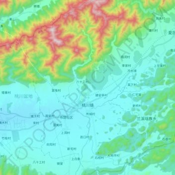
Name: 桃川镇 topographic map, elevation, terrain.

Location: 桃川镇, 江永县, 永州市, 湖南省, 425400, 中国 (25.04090 111.02224 25.21797 111.17179)

Average elevation: 380 m

Minimum elevation: 199 m

Maximum elevation: 1,124 m

Other topographic maps

Click on a map to view its topography, its elevation and its terrain.

千家峒瑶族乡

中国 > 湖南省 > 江永县

千家峒瑶族乡, 江永县, 永州市, 湖南省, 中国

Average elevation: 543 m

兴隆村

中国 > 湖南省 > 江永县 > 回龙圩镇

兴隆村, 回龙圩镇, 回龙圩管理区, 江永县, 永州市, 湖南省, 中国

Average elevation: 391 m

玉井

中国 > 湖南省 > 江永县 > 千家峒瑶族乡

玉井, 玉井村, 千家峒瑶族乡, 江永县, 永州市, 湖南省, 425400, 中国

Average elevation: 266 m

花果山

中国 > 湖南省 > 江永县 > 上江圩镇

花果山, 上江圩镇, 江永县, 永州市, 湖南省, 中国

Average elevation: 298 m

江永县

中国 > 湖南省 > 江永县 > 潇浦镇

江永县, 潇浦镇, 江永县, 永州市, 湖南省, 425400, 中国

Average elevation: 470 m