
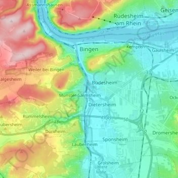
Bingen am Rhein topographic map
Interactive map
Click on the map to display elevation.
About this map
Name: Bingen am Rhein topographic map, elevation, terrain.
Average elevation: 172 m
Minimum elevation: 77 m
Maximum elevation: 391 m
Bingen am Rhein is een stad in de Duitse deelstaat Rijnland-Palts, gelegen in de Landkreis Mainz-Bingen op Rk 527. De stad telt 25.736 inwoners. Bingen is vooral bekend om het Klooster Rupertsberg dat rond 1150 door Hildegard von Bingen werd gebouwd en in 1152 door Hendrik I van Mainz werd geconsacreerd. Hoog boven de stad de Rochuskapelle met het door Goethe geschonken schilderij van de heilige Rochus. Verder is er dicht bij de stad de Burcht Klopp, een hoogteburcht.
Other topographic maps
Click on a map to view its topography, its elevation and its terrain.
Ingelheim am Rhein
Duitsland > Rijnland-Palts > Landkreis Mainz-Bingen
Ingelheim am Rhein, Landkreis Mainz-Bingen, Rijnland-Palts, Duitsland
Average elevation: 157 m
Bacharach
Duitsland > Rijnland-Palts > Landkreis Mainz-Bingen
Bacharach, Rhein-Nahe, Landkreis Mainz-Bingen, Rijnland-Palts, 55422, Duitsland
Average elevation: 264 m
Breitscheid
Duitsland > Rijnland-Palts > Landkreis Mainz-Bingen > Breitscheid
Breitscheid, Rhein-Nahe, Landkreis Mainz-Bingen, Rijnland-Palts, Duitsland
Average elevation: 401 m