
Thank you for supporting this site ❤️
Make a donation
Make a donation
Clifton topographic map
Click on the map to display elevation.
Thank you for supporting this site ❤️
Make a donation
Make a donation
About this map
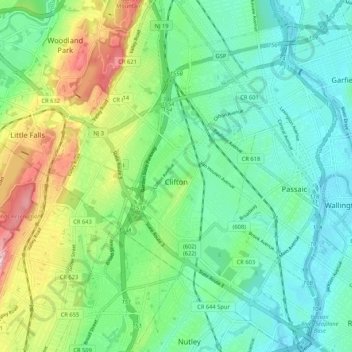
Name: Clifton topographic map, elevation, terrain.
Location: Clifton, Passaic County, New Jersey, United States (40.81993 -74.19773 40.89940 -74.11780)
Average elevation: 56 m
Minimum elevation: 1 m
Maximum elevation: 187 m
Thank you for supporting this site ❤️
Make a donation
Make a donation
Other topographic maps
Click on a map to view its topography, its elevation and its terrain.