Geolocate

Great Dividing Range topographic map

Click on the map to display elevation.

About this map

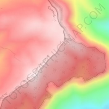
Name: Great Dividing Range topographic map, elevation, terrain.

Location: Great Dividing Range, The Falls, Southern Downs Regional, Queensland, Australia (-28.33655 152.41452 -28.33638 152.41483)

Average elevation: 939 m

Minimum elevation: 566 m

Maximum elevation: 1,080 m

Other topographic maps

Click on a map to view its topography, its elevation and its terrain.

Brisbane

Australia > Queensland > Brisbane

Average elevation: 45 m

Toowoomba

Australia > Queensland

The city occupies the edge of the range and the low ridges behind it. Two valleys run north from the southern boundary, each arising from springs either side of Middle Ridge near Spring Street at an altitude of around 680 m. These waterways, East Creek and West Creek, flow together just north of the CBD to…

Average elevation: 458 m

Gold Coast

Australia > Queensland

Average elevation: 42 m

Cairns

Australia > Queensland

South of Smithfield and inland from the Northern Beaches along the edge of the Barron River flood plain are the suburbs of Caravonica, Kamerunga, Freshwater, and Stratford. This area is sometimes referred to as Freshwater Valley, though it is actually the lower part of Redlynch Valley; further up the valley…

Average elevation: 176 m

Bundaberg

Australia > Queensland

Average elevation: 18 m

Sunshine Coast

Australia > Queensland > Sunshine Coast Regional

The Sunshine Coast in Queensland, Australia, showcases a diverse topography that harmoniously blends coastal plains with rugged hinterlands. Along its eastern edge, the region features expansive sandy beaches and coastal dunes that transition smoothly into fertile lowlands. Inland, the terrain becomes more…

Average elevation: 109 m

Mackay

Australia > Queensland

Average elevation: 13 m

City of Brisbane

Australia > Queensland

Brisbane's topography is characterized by a series of hills and ranges that define its landscape. The city is situated on a low-lying floodplain, with the Brisbane River meandering through its heart, creating a winding course with many steep curves from the southwest to its mouth at Moreton Bay in the east.…

Average elevation: 71 m

Rockhampton

Australia > Queensland

Average elevation: 48 m

Russell Island

Australia > Queensland

Average elevation: 8 m

Hervey Bay

Australia > Queensland

Average elevation: 6 m

Brisbane

Australia > Queensland

Average elevation: 87 m

Mitchell

Australia > Queensland

Average elevation: 375 m

Herbert River

Australia > Queensland

With its headwaters forming at an elevation of 1,070 metres (3,510 ft) on the Atherton Tableland, part of the Great Dividing Range west of Herberton and north of Ravenshoe, the Herbert River is formed by the confluence of the Millstream and the Wild River. The Herbert River flows in a generally southeastern…

Average elevation: 458 m

Mount Glorious

Australia > Queensland

Average elevation: 486 m

Caloundra

Australia > Queensland > Sunshine Coast Regional

Caloundra, located on Queensland's Sunshine Coast, features a diverse coastal topography characterized by sandy beaches, rocky headlands, and nearby elevated terrains. The suburb of Kings Beach exemplifies this diversity, with its sandy shoreline to the south and southeast, and a rocky headland rising to about…

Average elevation: 5 m

Ipswich

Australia > Queensland > Ipswich

Average elevation: 73 m

Charters Towers

Australia > Queensland

Average elevation: 302 m

Kowanyama

Australia > Queensland

Average elevation: 11 m

Redcliffe

Australia > Queensland

Average elevation: 9 m

Gold Coast City

Australia > Queensland

Average elevation: 87 m

Somerset Regional

Australia > Queensland

Average elevation: 274 m

Lockyer Valley Regional

Australia > Queensland

Average elevation: 360 m

Paddington

Australia > Queensland

Average elevation: 29 m

Fitzroy River

Australia > Queensland

Average elevation: 89 m

Carmila

Australia > Queensland

Average elevation: 159 m

Fernvale

Australia > Queensland

Average elevation: 64 m

Mount Coolum

Australia > Queensland > Maroochydore

Average elevation: 16 m

Townsville

Australia > Queensland

Average elevation: 30 m

Gladstone

Australia > Queensland

Average elevation: 24 m

Wivenhoe Dam

Australia > Queensland

Average elevation: 62 m

Scenic Rim Regional

Australia > Queensland

Average elevation: 261 m

Mount Cotton

Australia > Queensland

Average elevation: 105 m

Proserpine

Australia > Queensland

Average elevation: 10 m

Tamborine Mountain

Australia > Queensland

Average elevation: 447 m

Innisfail

Australia > Queensland

Average elevation: 12 m

Whitsundays

Australia > Queensland

Average elevation: 16 m

Burdekin River

Australia > Queensland

Average elevation: 293 m

Mount Mee

Australia > Queensland

Average elevation: 416 m

Babinda

Australia > Queensland

Average elevation: 120 m

Alexandra Hills

Australia > Queensland

Scribbly Gums Conservation Area is located on the eastern edge of Alexandra Hills, bordered by Redland Hospital to the east, and Flinders St and Winchester Rd to the north. The conservation area occupies approximately 152 hectares and contains the Redlands Track Park - a collection of 30+ mountain bike trails…

Average elevation: 34 m

Burpengary

Australia > Queensland

Average elevation: 26 m

St Lucia

Australia > Queensland

Average elevation: 18 m

Sippy Downs

Australia > Queensland

Average elevation: 12 m

St Lawrence

Australia > Queensland

Average elevation: 139 m

Prince Of Wales

Australia > Queensland

Average elevation: 18 m

Yarrabilba

Australia > Queensland

Average elevation: 63 m

Eungella

Australia > Queensland

Average elevation: 726 m

Sarina

Australia > Queensland

Average elevation: 129 m

Boyland

Australia > Queensland

Average elevation: 109 m

Bowen

Australia > Queensland

Average elevation: 64 m

Gordonvale

Australia > Queensland

Average elevation: 98 m

Hughenden

Australia > Queensland

Average elevation: 331 m

Ayr

Australia > Queensland

Average elevation: 9 m

Mount Larcom

Australia > Queensland

Average elevation: 93 m

Ingham

Australia > Queensland

Average elevation: 13 m

Giru

Australia > Queensland

Average elevation: 5 m

Innisfail

Australia > Queensland

Average elevation: 7 m

Montville

Australia > Queensland > Montville

Average elevation: 261 m

Warwick

Australia > Queensland > Warwick

Warwick has a humid subtropical climate (Köppen Cfa) with hot summers and cool to cold winters. It is slightly cooler and less humid than the proximate southeast Queensland coast due to its inland, elevation location. Frost is present in winter. The climate bears similarities with Richmond, an inland suburb…

Average elevation: 517 m

D'Aguilar National Park

Australia > Queensland

Average elevation: 139 m

Burnett River

Australia > Queensland

Average elevation: 189 m

Sandgate

Australia > Queensland > Brisbane City

Average elevation: 6 m

City of Brisbane

Australia > Queensland

Brisbane's topography is characterized by a series of hills and ranges that define its landscape. The city is situated on a low-lying floodplain, with the Brisbane River meandering through its heart, creating a winding course with many steep curves from the southwest to its mouth at Moreton Bay in the east.…

Average elevation: 71 m

Sunshine Coast Regional

Australia > Queensland

The Sunshine Coast Regional area in Queensland, Australia, features a diverse topography that ranges from coastal plains to rugged hinterlands. Along the coastline, the terrain is predominantly flat, with average elevations around 20 meters (66 feet) above sea level. Inland, the landscape transitions to…

Average elevation: 56 m

Coorparoo

Australia > Queensland

Average elevation: 27 m

Kureelpa

Australia > Queensland

Average elevation: 239 m

Pacific Pines

Australia > Queensland

Average elevation: 59 m

Weranga

Australia > Queensland

Average elevation: 370 m

Nambour

Australia > Queensland

Average elevation: 41 m

Margate

Australia > Queensland

Average elevation: 12 m

Brisbane River

Australia > Queensland

Riverfire, which began in 1998, was a festival held in September each year at South Bank Parklands and surrounding areas (including the Victoria Bridge), to celebrate the Brisbane River. In 2009, the festival merged with Brisbane Festival. Riverfire, which was held at the end of the Brisbane Festival until…

Average elevation: 44 m

Pomona

Australia > Queensland

Average elevation: 114 m

Cooroy

Australia > Queensland

Average elevation: 123 m

Blenheim

Australia > Queensland

Average elevation: 194 m

Port Stewart

Australia > Queensland

Average elevation: 2 m

Mount Isa

Australia > Queensland

Average elevation: 391 m

Bowen

Australia > Queensland > Bowen

Average elevation: 5 m

Jimboomba

Australia > Queensland

Average elevation: 43 m

Bribie Island

Australia > Queensland

Average elevation: 44 m

Toowoomba City

Australia > Queensland > Toowoomba

Average elevation: 615 m

Hamilton Island

Australia > Queensland

Average elevation: 21 m

Mount Gravatt

Australia > Queensland

Average elevation: 70 m

Atherton Tableland

Australia > Queensland

Average elevation: 800 m

Runaway Bay

Australia > Queensland > Gold Coast City

Average elevation: 2 m

Western Downs Regional

Australia > Queensland

Average elevation: 338 m

Mount Coot-tha

Australia > Queensland > City of Brisbane

It is often claimed that Mount Coot-tha is the "highest point in Brisbane", but, as the elevations above show, the peak known as Mount Coot-tha is not even the highest peak of the mountain as a whole with both Constitution Hill and The Summit being higher. However, Mount Coot-tha has a lookout with unobscured…

Average elevation: 88 m

Bardon

Australia > Queensland > City of Brisbane

Average elevation: 62 m

Hinchinbrook Shire

Australia > Queensland

Average elevation: 241 m

Woree

Australia > Queensland

Average elevation: 26 m

Jindalee

Australia > Queensland

Average elevation: 23 m

Ferny Hills

Australia > Queensland

Average elevation: 100 m

Maranoa Regional

Australia > Queensland

Average elevation: 369 m