
Carlsgrün topographic map
Interactive map
Click on the map to display elevation.
About this map
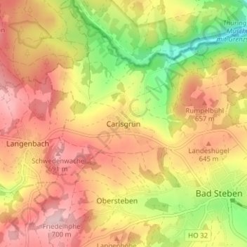
Name: Carlsgrün topographic map, elevation, terrain.
Average elevation: 612 m
Minimum elevation: 490 m
Maximum elevation: 703 m
Other topographic maps
Click on a map to view its topography, its elevation and its terrain.
Lochau
Deutschland > Bayern > Landkreis Hof > Bad Steben
Lochau, Bad Steben, Landkreis Hof, Bayern, 95138, Deutschland
Average elevation: 613 m
Thierbach
Deutschland > Bayern > Landkreis Hof > Bad Steben > Thierbach
Thierbach, Bad Steben, Landkreis Hof, Bayern, 95138, Deutschland
Average elevation: 569 m