
Thank you for supporting this site ❤️
Make a donation
Make a donation
Soulles topographic map
Click on the map to display elevation.
Thank you for supporting this site ❤️
Make a donation
Make a donation
About this map
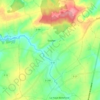
Name: Soulles topographic map, elevation, terrain.
Average elevation: 121 m
Minimum elevation: 79 m
Maximum elevation: 183 m
Thank you for supporting this site ❤️
Make a donation
Make a donation
Other topographic maps
Click on a map to view its topography, its elevation and its terrain.
Le Vert Buisson
France > Normandie > Manche > Bourgvallées > La Mancellière-sur-Vire
Average elevation: 56 m
La Mabilière
France > Normandie > Manche > Bourgvallées > Saint-Samson-de-Bonfossé
Average elevation: 93 m
Village de la Pasquerie
France > Normandie > Manche > Bourgvallées > Saint-Samson-de-Bonfossé
Average elevation: 104 m
Thank you for supporting this site ❤️
Make a donation
Make a donation