
东临溪镇 topographic map
Interactive map
Click on the map to display elevation.
About this map
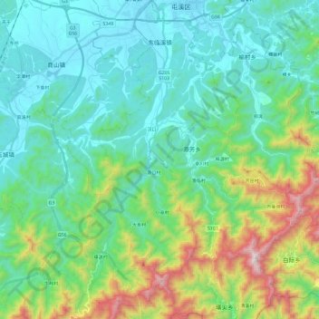
Name: 东临溪镇 topographic map, elevation, terrain.
Location: 东临溪镇, 休宁县, 黄山市, 安徽省, 中国 (29.49593 118.21883 29.70249 118.35359)
Average elevation: 385 m
Minimum elevation: 122 m
Maximum elevation: 1,259 m
Other topographic maps
Click on a map to view its topography, its elevation and its terrain.