
50420 topographic map
Interactive map
Click on the map to display elevation.
About this map
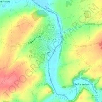
Name: 50420 topographic map, elevation, terrain.
Average elevation: 73 m
Minimum elevation: 37 m
Maximum elevation: 114 m
Other topographic maps
Click on a map to view its topography, its elevation and its terrain.
Les Hauts Vents
France > Normandie > Manche > Tessy-Bocage
Les Hauts Vents, Pont-Farcy, Tessy-Bocage, Saint-Lô, Manche, Normandie, France métropolitaine, 14380, France
Average elevation: 104 m
Beau Costil
France > Normandie > Manche > Tessy-Bocage
Beau Costil, Pont-Farcy, Tessy-Bocage, Saint-Lô, Manche, Normandie, France métropolitaine, 14380, France
Average elevation: 100 m
Tessy-sur-Vire
France > Normandie > Manche > Tessy-Bocage
Tessy-sur-Vire, Tessy-Bocage, Saint-Lô, Manche, Normandie, France métropolitaine, 50420, France
Average elevation: 93 m
La Furetière
France > Normandie > Manche > Tessy-Bocage
La Furetière, Tessy-sur-Vire, Tessy-Bocage, Saint-Lô, Manche, Normandie, France métropolitaine, 50420, France
Average elevation: 94 m
Le Moulin Sous Le Bois
France > Normandie > Manche > Tessy-Bocage > Le Moulin Sous Le Bois
Le Moulin Sous Le Bois, Pont-Farcy, Tessy-Bocage, Saint-Lô, Manche, Normandie, France métropolitaine, 14380, France
Average elevation: 98 m
Pont-Farcy
France > Normandie > Manche > Tessy-Bocage
Pont-Farcy, Tessy-Bocage, Saint-Lô, Manche, Normandie, France métropolitaine, 14380, France
Average elevation: 108 m
la campagne
France > Normandie > Manche > Tessy-Bocage > la campagne
la campagne, Tessy-sur-Vire, Tessy-Bocage, Saint-Lô, Manche, Normandie, France métropolitaine, 50420, France
Average elevation: 74 m