
Apeldoorn topographic map
Interactive map
Click on the map to display elevation.
About this map
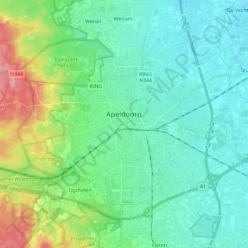
Name: Apeldoorn topographic map, elevation, terrain.
Location: Apeldoorn, Gelderland, Netherlands (52.17264 5.89263 52.25026 6.05825)
Average elevation: 26 m
Minimum elevation: 3 m
Maximum elevation: 99 m
Other topographic maps
Click on a map to view its topography, its elevation and its terrain.
Barneveld
Netherlands > Gelderland > Barneveld
Barneveld, Gelderland, Netherlands
Average elevation: 12 m
Doetinchem
Netherlands > Gelderland > Doetinchem
Doetinchem, Gelderland, Netherlands
Average elevation: 17 m