
五泥沟 topographic map
Interactive map
Click on the map to display elevation.
About this map
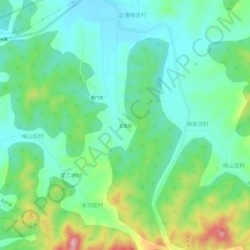
Name: 五泥沟 topographic map, elevation, terrain.
Location: 五泥沟, 高岭镇, 牟平区, 烟台市, 山东省, 264100, 中国 (37.22082 121.51447 37.26082 121.55447)
Average elevation: 116 m
Minimum elevation: 57 m
Maximum elevation: 262 m
Other topographic maps
Click on a map to view its topography, its elevation and its terrain.
烟台牟平山昔山-昆嵛山-大沽夹河-沁水河生物多样性维护生态保护I类红线区
烟台牟平山昔山-昆嵛山-大沽夹河-沁水河生物多样性维护生态保护I类红线区, 大商大街, 高岭镇, 牟平区, 烟台市, 山东省, 264100, 中国
Average elevation: 66 m