
Thank you for supporting this site ❤️
Make a donation
Make a donation
San Fernando topographic map
Click on the map to display elevation.
Thank you for supporting this site ❤️
Make a donation
Make a donation
About this map
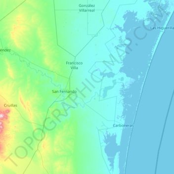
Name: San Fernando topographic map, elevation, terrain.
Location: San Fernando, Tamaulipas, 87605, Mexico (24.30054 -98.43041 25.44407 -97.51740)
Average elevation: 61 m
Minimum elevation: -3 m
Maximum elevation: 779 m
Thank you for supporting this site ❤️
Make a donation
Make a donation
Other topographic maps
Click on a map to view its topography, its elevation and its terrain.
Ciudad Victoria
Mexico > Tamaulipas > Victoria
Ciudad Victoria has a climate on the border of humid subtropical (Köppen Cfa/Cwa) and hot semi-arid (BSh). Its weather is characterised by short warm winters and long hot to sweltering summers. Temperatures rarely drop below 0 °C (32 °F) — the lowest recorded temperature was −6 °C (21.2 °F) and the…
Average elevation: 518 m
Thank you for supporting this site ❤️
Make a donation
Make a donation