
Dennison topographic map
Interactive map
Click on the map to display elevation.
About this map
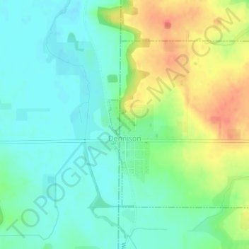
Name: Dennison topographic map, elevation, terrain.
Location: Dennison, Goodhue County, Minnesota, United States (44.39977 -93.04210 44.41788 -93.01984)
Average elevation: 303 m
Minimum elevation: 285 m
Maximum elevation: 334 m
Other topographic maps
Click on a map to view its topography, its elevation and its terrain.
Zumbrota
United States > Minnesota > Goodhue County
Zumbrota, Goodhue County, Minnesota, 55992, United States
Average elevation: 312 m
Kenyon
United States > Minnesota > Goodhue County
Kenyon, Goodhue County, Minnesota, United States
Average elevation: 351 m
Frontenac
United States > Minnesota > Goodhue County
Frontenac, Florence Township, Goodhue County, Minnesota, 55026, United States
Average elevation: 243 m
Red Wing
United States > Minnesota > Goodhue County
Red Wing, Goodhue County, Minnesota, United States
Average elevation: 263 m
Goodhue
United States > Minnesota > Goodhue County
Goodhue, Goodhue County, Minnesota, 55027, United States
Average elevation: 346 m
Wanamingo
United States > Minnesota > Goodhue County
Wanamingo, Goodhue County, Minnesota, 55983, United States
Average elevation: 325 m
Pine Island
United States > Minnesota > Goodhue County
Pine Island, Goodhue County, Minnesota, United States
Average elevation: 327 m
Welch
United States > Minnesota > Goodhue County
Welch, Welch Township, Goodhue County, Minnesota, United States
Average elevation: 277 m
Cannon Falls
United States > Minnesota > Goodhue County > Cannon Falls > Cannon Falls
Cannon Falls, Goodhue County, Minnesota, 55009, United States
Average elevation: 268 m
Cannon Falls
United States > Minnesota > Goodhue County
Cannon Falls, Goodhue County, Minnesota, 55009, United States
Average elevation: 276 m