
Wolong National Nature Reserve topographic map
Interactive map
Click on the map to display elevation.
Wolong National Nature Reserve
The giant panda is the most famous species of the reserve. Other typical larger Carnivora are the Ussuri dhole, Asian black bear, Asiatic golden cat, clouded leopard, red panda, hog badger and yellow-throated marten. Hooved mammals are represented by Sichuan takins, wild boar, musk deer, mainland serows, Chinese gorals, tufted deer and sambar deer. Other noticeable mammals include golden snub-nosed monkeys, Tibetan macaques, complex-toothed flying squirrels, bamboo rats, and porcupines. Because the reserve comprises different altitudes, it includes tropical and temperate climate zones and harbors species typically for the tropics, like sambar deer as well as species from temperate regions, like white-lipped deer, snow leopards and Turkestan lynxes. Camera-trap surveys conducted in the reserve area between 2005 and 2009 did not record any leopard. In 2018, a leopard was photographed by a camera trap at an elevation of 4,080 m (13,390 ft). The same camera, installed in 2017, also captured images of snow leopards seven times.
About this map
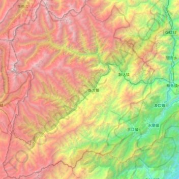
Name: Wolong National Nature Reserve topographic map, elevation, terrain.
Average elevation: 3,044 m
Minimum elevation: 640 m
Maximum elevation: 6,201 m
Other topographic maps
Click on a map to view its topography, its elevation and its terrain.