
Thank you for supporting this site ❤️
Make a donation
Make a donation
Fonte Tettone topographic map
Click on the map to display elevation.
Thank you for supporting this site ❤️
Make a donation
Make a donation
About this map
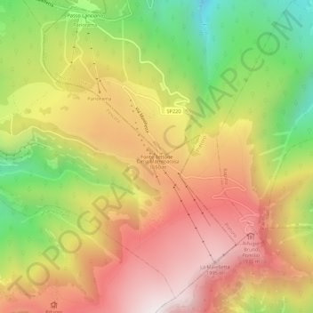
Name: Fonte Tettone topographic map, elevation, terrain.
Location: Fonte Tettone, Roccamorice, Pescara, Abruzzo, Italy (42.15096 14.09631 42.19096 14.13631)
Average elevation: 1,507 m
Minimum elevation: 860 m
Maximum elevation: 2,067 m
Thank you for supporting this site ❤️
Make a donation
Make a donation