Geolocate

Ligurian Alps topographic map

Click on the map to display elevation.

Ligurian Alps

The chief peak of the Western Ligurian Alps is Punta Marguareis (2,651 m), and there are several other summits over 2000 m, while in Eastern Ligurian Alps (also called Ligurian Prealps) the maximum elevation is 1739 m (Monte Armetta).

Wikipedia (CC-BY-SA 3.0)

About this map

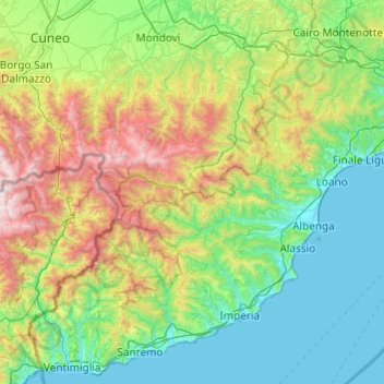
Name: Ligurian Alps topographic map, elevation, terrain.

Location: Ligurian Alps, Piedmont, Italy (43.77569 7.48916 44.44165 8.45642)

Average elevation: 663 m

Minimum elevation: 0 m

Maximum elevation: 2,876 m

Other topographic maps

Click on a map to view its topography, its elevation and its terrain.

Agrate

Italy > Piedmont > Novara

Average elevation: 324 m

Turin

Italy > Piedmont > Turin

Average elevation: 295 m

Blanc

Italy > Piedmont > Turin > San Germano Chisone

Average elevation: 831 m

Villaretto

Italy > Piedmont > Cuneo > Pontechianale

Average elevation: 1,807 m

Zoverallo

Italy > Piedmont > Verbano-Cusio-Ossola > Verbania

Average elevation: 322 m

Sportinia

Italy > Piedmont > Turin > Sauze d'Oulx

Average elevation: 2,015 m

Baltigati

Italy > Piedmont > Biella > Ponzone

Average elevation: 541 m

Monviso

Italy > Piedmont > Cuneo > Pontechianale

Monte Viso is the location of a Neolithic jadeite quarry, at an elevation of 2,000 to 2,400 metres. Its productivity peaked around 5000 BC. The jadeite was used to make cult axes, which are found all over western Europe. One such ceremonial axe head was found as far away as a small hill called Tristia in…

Average elevation: 2,985 m

Turin

Italy > Piedmont > Turin

Average elevation: 295 m

Norastra

Italy > Piedmont > Cuneo > Melle

Average elevation: 1,128 m

Blanc

Italy > Piedmont > Torino > San Germano Chisone

Average elevation: 831 m

Prato Nevoso

Italy > Piedmont > Cuneo

Average elevation: 1,436 m

Cascata

Italy > Piedmont > Verbano-Cusio-Ossola > Formazza

Average elevation: 1,990 m

Rocchetta

Italy > Piedmont > Cuneo

Average elevation: 702 m

Castello

Italy > Piedmont > Cuneo > Isasca

Average elevation: 756 m

Pratobotrile

Italy > Piedmont > Turin > Condove

Average elevation: 1,117 m

Monviso

Italy > Piedmont > Cuneo > Pontechianale

Monte Viso is the location of a neolithic jadeite quarry, at an elevation of 2000 to 2400 metres. Its productivity peaked around 5000 BC. The jadeite was used to make cult axes, which are found all over western Europe. One such ceremonial axe head was found as far away as a small hill called Tristia in Western…

Average elevation: 2,985 m

Puy

Italy > Piedmont > Cuneo > Casteldelfino

Average elevation: 1,718 m

Valle Mosso

Italy > Piedmont > Biella

Average elevation: 592 m

Spinetta

Italy > Piedmont > Cuneo > Cuneo

Average elevation: 525 m

Vandorno

Italy > Piedmont > Biella > Biella

Average elevation: 484 m

Turin

Italy > Piedmont > Turin

Average elevation: 295 m

Croce di Envie - Cima Bracco

Italy > Piedmont > Cuneo > Sanfront

The Monte Bracco (though the name is sometimes shortened to Mombracco) is a mountain in the Cottian Alps with an elevation of 1,307 meters above sea level. It is located between the Valle Po, the Valle Infernotto [it], and the Cuneo plain.

Average elevation: 947 m

Rosingo

Italy > Piedmont > Alessandria > Cerrina Monferrato

Average elevation: 234 m

Chionea

Italy > Piedmont > Cuneo > Ormea

Average elevation: 1,106 m

Castello

Italy > Piedmont > Verbano-Cusio-Ossola > Varzo

Average elevation: 978 m

Rivetto

Italy > Piedmont > Turin > San Giorio di Susa

Average elevation: 583 m

Fatiga

Italy > Piedmont > Cuneo > Dronero

Average elevation: 1,085 m

Magnoletto

Italy > Piedmont > Turin > Condove

Average elevation: 699 m

Prà della Marta

Italy > Piedmont > Verbano-Cusio-Ossola > Brolo

Average elevation: 491 m

Ruse

Italy > Piedmont > Vercelli > Varallo > I Prati

Average elevation: 787 m

Suppo

Italy > Piedmont > Turin > Rubiana

Average elevation: 1,350 m

Tampa Giasset

Italy > Piedmont > Cuneo > Crissolo

Average elevation: 1,940 m

Tetto Corvo

Italy > Piedmont > Cuneo > Cuneo

Average elevation: 472 m

Rivera

Italy > Piedmont > Torino > Almese

Average elevation: 481 m

Vigna

Italy > Piedmont > Cuneo

Average elevation: 912 m

Valmala

Italy > Piedmont > Cuneo > Busca

Average elevation: 995 m

Grange

Italy > Piedmont > Torino > Fenestrelle

Average elevation: 1,430 m

Valle Scura

Italy > Piedmont > Alessandria > Brignano-Frascata

Average elevation: 396 m

Maffiotto

Italy > Piedmont > Torino > Condove

Average elevation: 1,207 m

Fantone

Italy > Piedmont > Biella > Mosso Santa Maria

Average elevation: 765 m

Radice

Italy > Piedmont > Cuneo > Frassino

Average elevation: 1,100 m

Martini

Italy > Piedmont > Cuneo > Sampeyre

Average elevation: 1,302 m

Airetta

Italy > Piedmont > Cuneo > Paesana

Average elevation: 778 m

Coldimosso

Italy > Piedmont > Torino > Susa

Average elevation: 631 m

Valmosca

Italy > Piedmont > Biella > Campiglia Cervo

Average elevation: 1,223 m

Pisogno

Italy > Piedmont > Novara > Miasino

Average elevation: 527 m

Cireggio

Italy > Piedmont > Verbano-Cusio-Ossola > Omegna

Average elevation: 514 m

Valley Pellice

Italy > Piedmont > Torino > Villar Pellice

Average elevation: 1,338 m

Siberia

Italy > Piedmont > Torino

Average elevation: 186 m

Sn2

Italy > Piedmont > Vercelli > Boccioleto

Average elevation: 1,290 m

Margheria

Italy > Piedmont > Torino > Mathi

Average elevation: 422 m

Asmara

Italy > Piedmont > Biella > Campiglia Cervo

Average elevation: 1,112 m

Castagneretto

Italy > Piedmont > Torino > Villar Focchiardo

Average elevation: 643 m

Molini

Italy > Piedmont > Alessandria > Fraconalto

Average elevation: 624 m

Bose

Italy > Piedmont > Biella > Valle Mosso

Average elevation: 587 m

Pianezze

Italy > Piedmont > Biella > Camandona

Average elevation: 683 m

Trappa - Bagneri

Italy > Piedmont > Biella > Sordevolo

Average elevation: 1,045 m

Brusch

Italy > Piedmont > Cuneo > Barge

Average elevation: 397 m

Fornaci

Italy > Piedmont > Torino > Beinasco

Average elevation: 262 m

Acquarossa

Italy > Piedmont > Torino > Rubiana

Average elevation: 1,129 m

Gaggiolo

Italy > Piedmont > Novara

Average elevation: 211 m

Rivò

Italy > Piedmont > Biella > Viera

Average elevation: 831 m

Carena

Italy > Piedmont > Cuneo > Cherasco

Average elevation: 293 m

Tornetti

Italy > Piedmont > Turin > Viù

Average elevation: 1,333 m

Mucengo

Italy > Piedmont > Biella > Pray

Average elevation: 528 m

Clots

Italy > Piedmont > Torino > Oulx

Average elevation: 1,445 m

Tornetti

Italy > Piedmont > Torino > Viù

Average elevation: 1,333 m

Fontana dello Zolfo

Italy > Piedmont > Vercelli > Trino

Average elevation: 149 m

Monviso

Italy > Piedmont > Cuneo > Pontechianale

Monte Viso is the location of a neolithic jadeite quarry, at an elevation of 2,000 to 2,400 metres. Its productivity peaked around 5000 BC. The jadeite was used to make cult axes, which are found all over western Europe. One such ceremonial axe head was found as far away as a small hill called Tristia in…

Average elevation: 2,985 m

Grange

Italy > Piedmont > Torino > Fenestrelle

Average elevation: 1,430 m

Lucco

Italy > Piedmont > Torino > Val della Torre

Average elevation: 861 m

Oasi Zegna

Italy > Piedmont > Biella > Guala

Average elevation: 1,028 m

Rialmosso

Italy > Piedmont > Biella > Campiglia Cervo

Average elevation: 1,051 m

Bulliana

Italy > Piedmont > Biella

Average elevation: 770 m

Nicoletto

Italy > Piedmont > Biella > Valle Mosso

Average elevation: 593 m

Foresto

Italy > Piedmont > Torino > Bussoleno

Average elevation: 710 m

Foresto

Italy > Piedmont > Vercelli > Borgosesia

Average elevation: 647 m

Zanco

Italy > Piedmont > Alessandria > Villadeati

Average elevation: 241 m

Crocemosso

Italy > Piedmont > Biella > Aviè

Average elevation: 595 m

Triverio

Italy > Piedmont > Biella > Bioglio

Average elevation: 550 m

Dagostino

Italy > Piedmont > Biella > Camandona

Average elevation: 704 m

Alpe Savolere

Italy > Piedmont > Torino > Locana

Average elevation: 2,208 m

Priacco

Italy > Piedmont > Torino > Cuorgnè

Average elevation: 525 m

Costa Bugni

Italy > Piedmont > Torino > Rosone

Average elevation: 1,230 m

Frais

Italy > Piedmont > Torino > Chiomonte

Average elevation: 1,462 m

Ciglione

Italy > Piedmont > Alessandria > Ponzone

Average elevation: 387 m

Saretto

Italy > Piedmont > Cuneo > Dronero

Average elevation: 1,033 m

Borgo di Valcasotto

Italy > Piedmont > Cuneo > Pamparato

Average elevation: 1,223 m

San Sebastiano

Italy > Piedmont > Cuneo > Marmora

Average elevation: 1,722 m

Mottarone

Italy > Piedmont > Verbano-Cusio-Ossola > Stresa

Mottarone is a mountain in the Western Alps of Piedmont, north-western Italy, with an elevation of 1,492 metres (4,895 ft). It is located between the provinces of Verbano-Cusio-Ossola and Novara.

Average elevation: 1,177 m

Fasi

Italy > Piedmont > Cuneo > Frassino

Average elevation: 1,130 m

San Maurizio

Italy > Piedmont > Cuneo > Frassino

Average elevation: 1,106 m

Pianezza

Italy > Piedmont > Verbano-Cusio-Ossola > Bolco

Average elevation: 615 m

Frieri

Italy > Piedmont > Biella > Bulliana

Average elevation: 762 m

Frieri

Italy > Piedmont > Torino > Villar Perosa

Average elevation: 753 m

San Giorgio

Italy > Piedmont > Torino > Monastero di Lanzo

Average elevation: 955 m

Pugnetto

Italy > Piedmont > Torino > Mezzenile

Average elevation: 847 m