Geolocate

闾井镇 topographic map

Interactive map

Click on the map to display elevation.

About this map

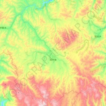
Name: 闾井镇 topographic map, elevation, terrain.

Location: 闾井镇, 岷县, 定西市, 甘肃省, 中国 (34.19409 104.39564 34.48102 104.69159)

Average elevation: 2,814 m

Minimum elevation: 2,295 m

Maximum elevation: 3,476 m

Other topographic maps

Click on a map to view its topography, its elevation and its terrain.

土地眼

中国 > 甘肃省 > 岷县 > 马坞镇

土地眼, 马坞镇, 岷县, 定西市, 甘肃省, 中国

Average elevation: 2,349 m

岷县龙望台水电集团有限责任公司

中国 > 甘肃省 > 岷县 > 的西

岷县龙望台水电集团有限责任公司, 的西, 岷县, 定西市, 甘肃省, 中国

Average elevation: 2,446 m

岷县

中国 > 甘肃省 > 岷县

岷县, 定西市, 甘肃省, 748400, 中国

Average elevation: 2,695 m

二郎山

中国 > 甘肃省 > 岷县 > 岷县

二郎山, 岷县, 定西市, 甘肃省, 74800, 中国

Average elevation: 2,356 m

岷山

中国 > 甘肃省 > 岷县

岷山, 岷县, 定西市, 甘肃省, 中国

Average elevation: 2,403 m