
Vista topographic map
Interactive map
Click on the map to display elevation.
About this map
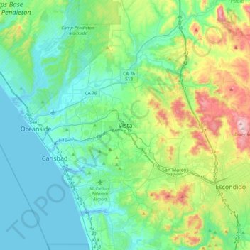
Name: Vista topographic map, elevation, terrain.
Location: Vista, San Diego County, California, 92083, United States (33.04004 -117.40254 33.36004 -117.08254)
Average elevation: 142 m
Minimum elevation: -5 m
Maximum elevation: 635 m
Other topographic maps
Click on a map to view its topography, its elevation and its terrain.
Ocean Hills
United States > California > San Diego County > Vista
Ocean Hills, Vista, San Diego County, California, 92081, United States
Average elevation: 123 m
Buena Vista Creek
United States > California > San Diego County > Vista
Buena Vista Creek, Vista, San Diego County, California, 92083, United States
Average elevation: 117 m