
Thank you for supporting this site ❤️
Make a donation
Make a donation
Dagundalahon topographic map
Click on the map to display elevation.
Thank you for supporting this site ❤️
Make a donation
Make a donation
About this map
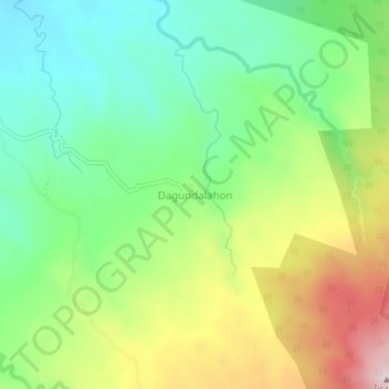
Name: Dagundalahon topographic map, elevation, terrain.
Location: Dagundalahon, Bukidnon, Northern Mindanao, 8708, Philippines (8.11893 124.64368 8.15893 124.68368)
Average elevation: 697 m
Minimum elevation: 508 m
Maximum elevation: 1,010 m
Thank you for supporting this site ❤️
Make a donation
Make a donation