
Thank you for supporting this site ❤️
Make a donation
Make a donation
Patiala topographic map
Click on the map to display elevation.
Thank you for supporting this site ❤️
Make a donation
Make a donation
Patiala
Patiala is located at 30°19′N 76°24′E / 30.32°N 76.40°E / 30.32; 76.40. It has an average elevation of 250 metres (820 feet). During the short existence of PEPSU, Patiala served as its capital city.
Thank you for supporting this site ❤️
Make a donation
Make a donation
About this map
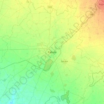
Name: Patiala topographic map, elevation, terrain.
Location: Patiala, Patiala Tahsil, Patiala, Punjab, 147001, India (30.16956 76.25278 30.48956 76.57278)
Average elevation: 255 m
Minimum elevation: 241 m
Maximum elevation: 274 m
Thank you for supporting this site ❤️
Make a donation
Make a donation