
Schendelbeke topographic map
Interactive map
Click on the map to display elevation.
About this map
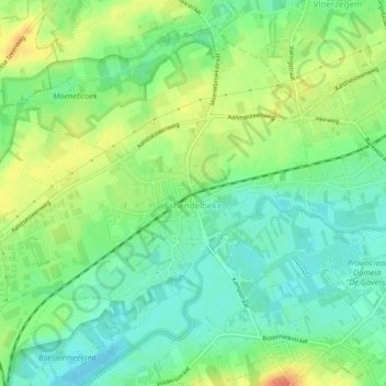
Name: Schendelbeke topographic map, elevation, terrain.
Average elevation: 24 m
Minimum elevation: 6 m
Maximum elevation: 51 m
Le village est situé le long de la Dendre. L'altitude varie de 20 à 40 mètres.
Other topographic maps
Click on a map to view its topography, its elevation and its terrain.
Onkerzele
Belgique > Flandre orientale > Alost > Grammont
Onkerzele, Grammont, Alost, Flandre orientale, Flandre, Belgique
Average elevation: 38 m