
Coniston topographic map
Interactive map
Click on the map to display elevation.
About this map
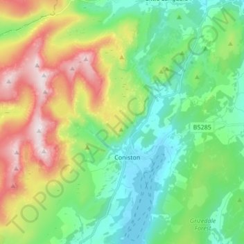
Name: Coniston topographic map, elevation, terrain.
Average elevation: 289 m
Minimum elevation: 45 m
Maximum elevation: 796 m
Other topographic maps
Click on a map to view its topography, its elevation and its terrain.
Helsington
United Kingdom > England > South Lakeland
Helsington, South Lakeland, Cumbria, North West England, England, United Kingdom
Average elevation: 63 m