
Mount Makalu topographic map
Interactive map
Click on the map to display elevation.
About this map
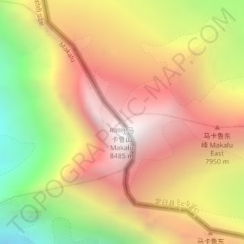
Name: Mount Makalu topographic map, elevation, terrain.
Location: Mount Makalu, Qutang, Tingri County, Shigatse, Tibet, China (27.89115 87.08859 27.89125 87.08869)
Average elevation: 7,484 m
Minimum elevation: 6,279 m
Maximum elevation: 8,389 m
Other topographic maps
Click on a map to view its topography, its elevation and its terrain.
Mount Everest
China > Tibet > Qutang > Khumjung
Mount Everest (Chinese: 珠穆朗玛 Zhūmùlǎngmǎ; Nepali: सगरमाथा, romanized: Sagarmāthā; Tibetan: Chomolungma ཇོ་མོ་གླང་མ) is Earth's highest mountain above sea level, located in the Mahalangur Himal sub-range of the Himalayas. The China–Nepal border runs across its…
Average elevation: 7,839 m