
Make a donation
Wolcott topographic map
Click on the map to display elevation.
Make a donation
Wolcott
The highest point in New Haven County is found in Wolcott atop Lindsley Hill, which has an elevation of approximately 1,046 feet above sea level.
Make a donation
About this map
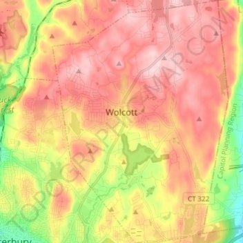
Name: Wolcott topographic map, elevation, terrain.
Average elevation: 209 m
Minimum elevation: 56 m
Maximum elevation: 320 m
Make a donation
Other topographic maps
Click on a map to view its topography, its elevation and its terrain.
Huntington
United States > Connecticut > Naugatuck Valley Planning Region > Shelton
Average elevation: 111 m
Minortown
United States > Connecticut > Naugatuck Valley Planning Region > Woodbury
Average elevation: 169 m
White Hills
United States > Connecticut > Naugatuck Valley Planning Region > Shelton
Average elevation: 124 m
Make a donation
Mad River
United States > Connecticut > Naugatuck Valley Planning Region > Waterbury > Fair Lawn
Average elevation: 134 m
Fox Hollow
United States > Connecticut > Naugatuck Valley Planning Region > Cheshire
Average elevation: 64 m
Westview Heights
United States > Connecticut > Naugatuck Valley Planning Region > Middlebury
Average elevation: 159 m
Union City
United States > Connecticut > Naugatuck Valley Planning Region > Naugatuck
Average elevation: 124 m
Make a donation
Warsaw Park
United States > Connecticut > Naugatuck Valley Planning Region > Ansonia
Average elevation: 107 m
Bunker Hill
United States > Connecticut > Naugatuck Valley Planning Region > Waterbury
Average elevation: 140 m
Cedar Land
United States > Connecticut > Naugatuck Valley Planning Region > Southbury
Average elevation: 103 m
Make a donation
Town Plot Hill
United States > Connecticut > Naugatuck Valley Planning Region > Waterbury
Average elevation: 127 m
Millville
United States > Connecticut > Naugatuck Valley Planning Region > Naugatuck
Average elevation: 132 m
Bunker Hill
United States > Connecticut > Naugatuck Valley Planning Region > Waterbury
Average elevation: 140 m
Bunker Hill
United States > Connecticut > Naugatuck Valley Planning Region > Waterbury
Average elevation: 140 m
Make a donation
Traditions
United States > Connecticut > Naugatuck Valley Planning Region > Southbury > South Britain
Average elevation: 112 m
Minortown
United States > Connecticut > Naugatuck Valley Planning Region > Woodbury
Average elevation: 169 m
Gulls Hollow
United States > Connecticut > Naugatuck Valley Planning Region > Bethlehem
Average elevation: 243 m
Allentown
United States > Connecticut > Naugatuck Valley Planning Region > Plymouth
Average elevation: 244 m
Make a donation