
Canneto topographic map
Interactive map
Click on the map to display elevation.
About this map
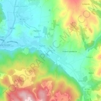
Name: Canneto topographic map, elevation, terrain.
Location: Canneto, Perugia, Umbria, 06133, Italia (43.13782 12.31518 43.17782 12.35518)
Average elevation: 377 m
Minimum elevation: 254 m
Maximum elevation: 587 m
Other topographic maps
Click on a map to view its topography, its elevation and its terrain.
Ponte Felcino
Italia > Umbria > Perugia > Perugia
Ponte Felcino, Perugia, Umbria, 06080, Italia
Average elevation: 262 m
Fontignano
Italia > Umbria > Perugia > Perugia
Fontignano, Perugia, Umbria, 06064, Italia
Average elevation: 271 m