
Thank you for supporting this site ❤️
Make a donation
Make a donation
Nimblewill topographic map
Click on the map to display elevation.
Thank you for supporting this site ❤️
Make a donation
Make a donation
About this map
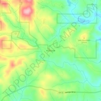
Name: Nimblewill topographic map, elevation, terrain.
Location: Nimblewill, Lumpkin County, Georgia, United States (34.54342 -84.16019 34.58342 -84.12019)
Average elevation: 528 m
Minimum elevation: 461 m
Maximum elevation: 631 m
Thank you for supporting this site ❤️
Make a donation
Make a donation
Other topographic maps
Click on a map to view its topography, its elevation and its terrain.