
Waldens Creek topographic map
Interactive map
Click on the map to display elevation.
About this map
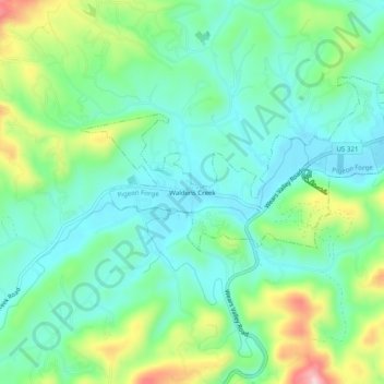
Name: Waldens Creek topographic map, elevation, terrain.
Average elevation: 362 m
Minimum elevation: 297 m
Maximum elevation: 521 m
Other topographic maps
Click on a map to view its topography, its elevation and its terrain.
Pine Grove
United States > Tennessee > Sevier County > Pigeon Forge
Pine Grove, Pigeon Forge, Sevier County, East Tennessee, Tennessee, 37862, United States
Average elevation: 315 m
Henderson Springs
United States > Tennessee > Sevier County > Pigeon Forge
Henderson Springs, Pigeon Forge, Sevier County, East Tennessee, Tennessee, 37862, United States
Average elevation: 329 m