
Thank you for supporting this site ❤️
Make a donation
Make a donation
Pindo Chico topographic map
Click on the map to display elevation.
Thank you for supporting this site ❤️
Make a donation
Make a donation
About this map
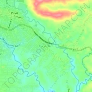
Name: Pindo Chico topographic map, elevation, terrain.
Location: Pindo Chico, Puyo, Pastaza, 160104, Ecuador (-1.51993 -78.00319 -1.47993 -77.96319)
Average elevation: 927 m
Minimum elevation: 887 m
Maximum elevation: 1,000 m
Thank you for supporting this site ❤️
Make a donation
Make a donation
Other topographic maps
Click on a map to view its topography, its elevation and its terrain.