
Make a donation
Cullinan topographic map
Click on the map to display elevation.
Make a donation
Cullinan
Cullinan is situated in the Highveld region of South Africa. The town has an elevation of 1476 m (4842.52 ft) and is located at −25.6709 [latitude in decimal degrees], 28.5236 [longitude in decimal degrees]. The closest city is Pretoria being 40 km (25 mi) away, while Johannesburg is 100 km (62 mi) away.
Make a donation
About this map
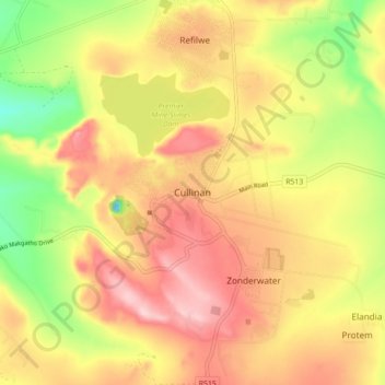
Name: Cullinan topographic map, elevation, terrain.
Average elevation: 1,420 m
Minimum elevation: 1,294 m
Maximum elevation: 1,521 m
Make a donation
Other topographic maps
Click on a map to view its topography, its elevation and its terrain.
Wierda Glen
South Africa > Gauteng > City of Tshwane Metropolitan Municipality > Simarlo AH
Average elevation: 1,479 m
Morula View Park
South Africa > Gauteng > City of Tshwane Metropolitan Municipality
Average elevation: 1,201 m
Centurion Lake
South Africa > Gauteng > City of Tshwane Metropolitan Municipality > Centurion
Average elevation: 1,440 m
Roodeplaat Dam
South Africa > Gauteng > City of Tshwane Metropolitan Municipality
Average elevation: 1,214 m
Make a donation
Tshwane Ward 105
South Africa > Gauteng > City of Tshwane Metropolitan Municipality
Average elevation: 1,442 m
Tshwane Ward 65
South Africa > Gauteng > City of Tshwane Metropolitan Municipality
Average elevation: 1,487 m
Bronkhorstspruit
South Africa > Gauteng > City of Tshwane Metropolitan Municipality
Average elevation: 1,502 m
Tshwane Ward 54
South Africa > Gauteng > City of Tshwane Metropolitan Municipality
Average elevation: 1,287 m
Make a donation
Rietvlei Dam
South Africa > Gauteng > City of Tshwane Metropolitan Municipality > Doornkloof East
Average elevation: 1,489 m
Himalya Street Park
South Africa > Gauteng > City of Tshwane Metropolitan Municipality > Pretoria
Average elevation: 1,456 m
Make a donation
Bronkhorstspruit Dam
South Africa > Gauteng > City of Tshwane Metropolitan Municipality
Average elevation: 1,462 m
Tshwane Ward 100
South Africa > Gauteng > City of Tshwane Metropolitan Municipality
Average elevation: 1,408 m
Tshwane Ward 91
South Africa > Gauteng > City of Tshwane Metropolitan Municipality
Average elevation: 1,513 m
Tshwane Ward 53
South Africa > Gauteng > City of Tshwane Metropolitan Municipality
Average elevation: 1,312 m
Make a donation
Tshwane Ward 30
South Africa > Gauteng > City of Tshwane Metropolitan Municipality
Average elevation: 1,206 m
Bronkhorstspruit Dam
South Africa > Gauteng > City of Tshwane Metropolitan Municipality
Average elevation: 1,462 m