
Make a donation
West Bengal topographic map
Click on the map to display elevation.
Make a donation
West Bengal
The distribution of vegetation in northern West Bengal is dictated by elevation and precipitation. For example, the foothills of the Himalayas, the Dooars, are densely wooded with sal and other tropical evergreen trees. Above an elevation of 1,000 metres (3,300 ft), the forest becomes predominantly subtropical. In Darjeeling, which is above 1,500 metres (4,900 ft), temperate forest trees like oaks, conifers and rhododendrons predominate.
Make a donation
About this map
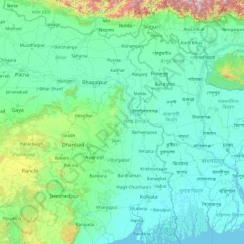
Name: West Bengal topographic map, elevation, terrain.
Location: West Bengal, India (21.54730 85.81967 27.22107 89.88260)
Average elevation: 182 m
Minimum elevation: -2 m
Maximum elevation: 4,101 m
Make a donation
Other topographic maps
Click on a map to view its topography, its elevation and its terrain.
Make a donation
Hisar
Hisar is located at 29°05′N 75°26′E / 29.09°N 75.43°E / 29.09; 75.43 in western Haryana. It has an average elevation of 215 m (705 ft) above sea level. The region is part of the alluvial Ghaggar-Yamuna plain and its southern and western portions mark a gradual transition to the desert. The…
Average elevation: 213 m
Mahad
India > Maharashtra > Mahad Taluka
Several disasters like floods and landslides have continuously devastated markets and old houses, specifically classic Konkani-styled architecture, causing great loss of life. This is primarily due to lower elevation of the city compared to surrounding areas and being surrounded by rivers on all sides, making…
Average elevation: 75 m
(Shree Pravshnath park )Prabhu Pravshnath nagar pal balaji
India > Rajasthan > Jodhpur Tehsil > Jodhpur
Average elevation: 231 m
Make a donation
Make a donation
Make a donation
Make a donation
Make a donation