
Thank you for supporting this site ❤️
Make a donation
Make a donation
Sungai Kenau topographic map
Click on the map to display elevation.
Thank you for supporting this site ❤️
Make a donation
Make a donation
About this map
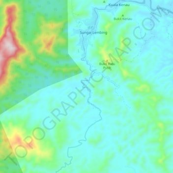
Name: Sungai Kenau topographic map, elevation, terrain.
Location: Sungai Kenau, Kuala Kenau, Kuantan, Pahang, Malaysia (3.84248 103.01527 3.93315 103.05090)
Average elevation: 141 m
Minimum elevation: 17 m
Maximum elevation: 662 m
Thank you for supporting this site ❤️
Make a donation
Make a donation
Other topographic maps
Click on a map to view its topography, its elevation and its terrain.