
Purayidathilkavu topographic map
Interactive map
Click on the map to display elevation.
About this map
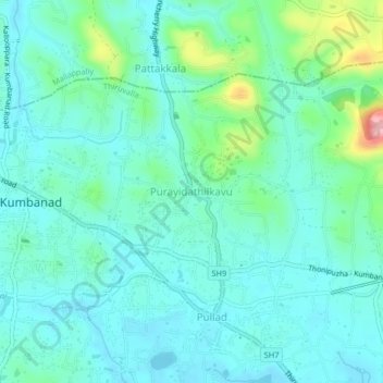
Name: Purayidathilkavu topographic map, elevation, terrain.
Average elevation: 36 m
Minimum elevation: 5 m
Maximum elevation: 160 m
Other topographic maps
Click on a map to view its topography, its elevation and its terrain.
Parumala
India > Kerala > Thiruvalla
Parumala, Thiruvalla, Pathanamthitta District, Kerala, 689626, India
Average elevation: 6 m
Kumbanad
India > Kerala > Thiruvalla
Kumbanad, Thiruvalla, Pathanamthitta District, Kerala, 689547, India
Average elevation: 24 m
Manackachira
India > Kerala > Thiruvalla > Eraviperoor
Manackachira, Eraviperoor, Thiruvalla, Pathanamthitta District, Kerala, 689541, India, Nellad
Average elevation: 12 m
Kaviyoor
India > Kerala > Thiruvalla > Kaniyanpara
Kaviyoor, Manackachira, Kaniyanpara, Thiruvalla, Pathanamthitta, Kerala, India
Average elevation: 15 m
Thiruvalla
India > Kerala > Thiruvalla
Thiruvalla, Pathanamthitta, Kerala, 689111, India
Average elevation: 10 m