
Đà Nẵng topographic map
Interactive map
Click on the map to display elevation.
Đà Nẵng
Geologically, Da Nang is at the edge of a Paleozoic fold belt known as the Truong Son Orogenic Zone, whose main deformation occurred during the early Carboniferous period. Da Nang's topography is dominated by the steep Annamite mountain range to the north and north-west, which features peaks ranging from 700 to 1,500 m (2,300 to 4,900 ft) in height, and low-lying coastal plains with some salting to the south and east, with several white sand beaches along the coast.
About this map
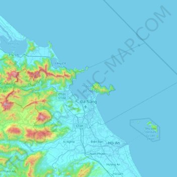
Name: Đà Nẵng topographic map, elevation, terrain.
Location: Đà Nẵng, Vietnam (15.91799 107.81854 16.33401 108.65637)
Average elevation: 99 m
Minimum elevation: -2 m
Maximum elevation: 1,662 m
Other topographic maps
Click on a map to view its topography, its elevation and its terrain.