
Mapleton topographic map
Click on the map to display elevation.
About this map
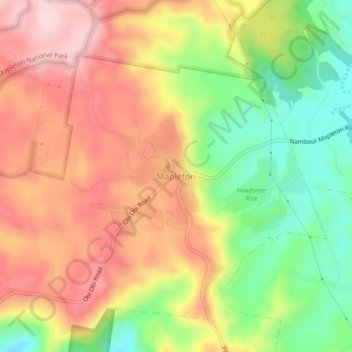
Name: Mapleton topographic map, elevation, terrain.
Location: Mapleton, Sunshine Coast Regional, Queensland, Australia (-26.64414 152.84616 -26.60414 152.88616)
Average elevation: 337 m
Minimum elevation: 202 m
Maximum elevation: 455 m
Other topographic maps
Click on a map to view its topography, its elevation and its terrain.
Minyama
Australia > Queensland > Sunshine Coast Regional
Minyama is located within the Kawana Waters urban centre. Situated on the Mooloolah River, the suburb is almost entirely surrounded by water, and artificially constructed harbours and waterways dominate the topography. The suburb's main thoroughfare, Nicklin Way, is the location of several large retail…
Average elevation: 3 m