
Thank you for supporting this site ❤️
Make a donation
Make a donation
Dawsonville topographic map
Click on the map to display elevation.
Thank you for supporting this site ❤️
Make a donation
Make a donation
About this map
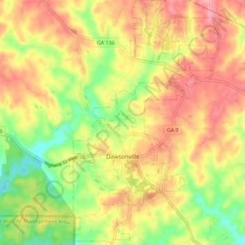
Name: Dawsonville topographic map, elevation, terrain.
Location: Dawsonville, Dawson County, Georgia, United States (34.39788 -84.13500 34.46249 -84.06178)
Average elevation: 412 m
Minimum elevation: 351 m
Maximum elevation: 462 m
Thank you for supporting this site ❤️
Make a donation
Make a donation
Other topographic maps
Click on a map to view its topography, its elevation and its terrain.