
Lynchburg topographic map
Interactive map
Click on the map to display elevation.
About this map
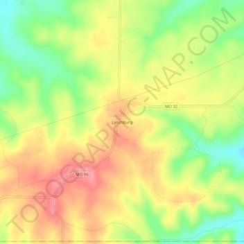
Name: Lynchburg topographic map, elevation, terrain.
Location: Lynchburg, Laclede County, Missouri, 65543, United States (37.47310 -92.31433 37.51310 -92.27433)
Average elevation: 400 m
Minimum elevation: 349 m
Maximum elevation: 444 m
Other topographic maps
Click on a map to view its topography, its elevation and its terrain.
Eldridge
United States > Missouri > Laclede County
Eldridge, Laclede County, Missouri, 65463, United States
Average elevation: 349 m
Conway
United States > Missouri > Laclede County > Conway
Conway, Laclede County, Missouri, United States
Average elevation: 416 m
Lebanon
United States > Missouri > Laclede County
Lebanon, Laclede County, Missouri, 65536, United States
Average elevation: 381 m