
Alshaheed Park topographic map
Interactive map
Click on the map to display elevation.
About this map
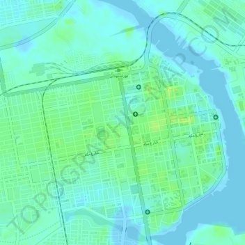
Name: Alshaheed Park topographic map, elevation, terrain.
Location: Alshaheed Park, Port Sudan, Red Sea State, Sudan (19.61845 37.21400 19.61934 37.21508)
Average elevation: 6 m
Minimum elevation: -10 m
Maximum elevation: 14 m
Other topographic maps
Click on a map to view its topography, its elevation and its terrain.
Suakin
Sudan > Red Sea State > Port Sudan
Suakin, Port Sudan, Red Sea State, Sudan
Average elevation: 14 m
Port Sudan
Sudan > Red Sea State > Port Sudan
Port Sudan, Red Sea State, 79800, Sudan
Average elevation: 50 m