
Thank you for supporting this site ❤️
Make a donation
Make a donation
Kabul topographic map
Click on the map to display elevation.
Thank you for supporting this site ❤️
Make a donation
Make a donation
Kabul
The modern-day city of Kabul is located high in a narrow valley in the Hindu Kush mountain range, and is bounded by the Kabul River. At an elevation of 1,790 metres (5,873 ft), it is one of the highest capital cities in the world. The center of the city contains its old neighborhoods, including the areas of Khashti Bridge, Khabgah, Kahforoshi, Deh-Afghanan, Chandavel, Shorbazar, Saraji and Baghe Alimardan.
Thank you for supporting this site ❤️
Make a donation
Make a donation
About this map
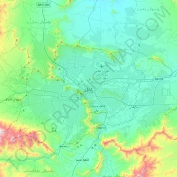
Name: Kabul topographic map, elevation, terrain.
Location: Kabul, Kabul District, Kabul Province, 1001, Afghanistan (34.36695 69.02506 34.68695 69.34506)
Average elevation: 1,938 m
Minimum elevation: 1,701 m
Maximum elevation: 3,000 m
Thank you for supporting this site ❤️
Make a donation
Make a donation
Other topographic maps
Click on a map to view its topography, its elevation and its terrain.