
Make a donation
Mannheim topographic map
Click on the map to display elevation.
Make a donation
About this map
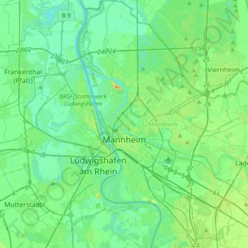
Name: Mannheim topographic map, elevation, terrain.
Location: Mannheim, Baden-Württemberg, Germany (49.41036 8.41416 49.59047 8.58999)
Average elevation: 97 m
Minimum elevation: 84 m
Maximum elevation: 140 m
Make a donation
Other topographic maps
Click on a map to view its topography, its elevation and its terrain.
Stuttgart
Germany > Baden-Württemberg > Stuttgart
Stuttgart covers an area of 207.35 km2 (80 sq mi) and sits at elevation ranging from 207 m (679 ft) above sea level by the Neckar river to 549 m (1,801 ft) on Bernhartshöhe hill – something rather unique in large German cities. The most prominent elevated locales in Stuttgart are the Birkenkopf (511 m…
Average elevation: 353 m
Rembrechts
Germany > Baden-Württemberg > Landkreis Ravensburg > Wangen im Allgäu > Haslach
Average elevation: 552 m
Make a donation
Sinsheim-Steinsfurt / Insenbach
Germany > Baden-Württemberg > Rhein-Neckar-Kreis > Sinsheim
Average elevation: 204 m
Hopfenweiler
Germany > Baden-Württemberg > Landkreis Ravensburg > Bad Waldsee
Average elevation: 618 m
Obergieß
Germany > Baden-Württemberg > Ortenaukreis > Hornberg > Niederwasser
Average elevation: 717 m
Make a donation
Make a donation
Make a donation
Riet
Germany > Baden-Württemberg > Landkreis Ludwigsburg > Vaihingen an der Enz
Average elevation: 311 m
Zieflensberg
Germany > Baden-Württemberg > Landkreis Calw > Bad Herrenalb > Zieflensberg
Average elevation: 668 m
Make a donation
Ground Zero
Germany > Baden-Württemberg > Landkreis Ludwigsburg > Ludwigsburg
Average elevation: 304 m
Wilflingen
Germany > Baden-Württemberg > Ostalbkreis > Abtsgmünd
The main town of Abtsgmünd lies at the confluence of the Lein river into the Kocher (confluence elevation 367.4 m above sea level), predominantly on the left bank of the Kocher and left bank of the Lein. The furthest district of Untergröningen lies over 8 km west-northwest as the crow flies along two river…
Average elevation: 432 m
Make a donation
Escheck
Germany > Baden-Württemberg > Schwarzwald-Baar-Kreis > Furtwangen im Schwarzwald
Average elevation: 1,011 m
Rielingshausen
Germany > Baden-Württemberg > Landkreis Ludwigsburg > Marbach am Neckar
Average elevation: 291 m
Make a donation
Obertüllingen
Germany > Baden-Württemberg > Landkreis Lörrach > Lörrach > Untertüllingen
Average elevation: 307 m
Nussdorf
Germany > Baden-Württemberg > Landkreis Ludwigsburg
The municipality (Gemeinde) of Eberdingen is located at the western extremity of the district of Ludwigsburg, in the German state of Baden-Württemberg, along its border with the districts of Böblingen and the Enz. Eberdingen is physically located in the basin of [de] the Neckar. Elevation above sea level in…
Average elevation: 321 m
Großherrischwand
Germany > Baden-Württemberg > Landkreis Waldshut > Herrischried
Average elevation: 920 m
Make a donation
Kleinallmerspann
Germany > Baden-Württemberg > Landkreis Schwäbisch Hall > Kirchberg an der Jagst
Average elevation: 430 m
Make a donation
Mattenhof
Germany > Baden-Württemberg > Ortenaukreis > Gutach (Schwarzwaldbahn)
Average elevation: 402 m
Hauenstein
Germany > Baden-Württemberg > Landkreis Waldshut > Laufenburg (Baden) > Luttingen
Average elevation: 383 m
Make a donation
Kapfenburg
Germany > Baden-Württemberg > Ostalbkreis > Lauchheim > Domäne Kapfenburg
Average elevation: 559 m
Make a donation
Steinbronnen
Germany > Baden-Württemberg > Landkreis Sigmaringen > Bad Saulgau > Bierstetten
Average elevation: 638 m
Ableitung Erms
Germany > Baden-Württemberg > Landkreis Reutlingen > Dettingen an der Erms
Average elevation: 482 m
Make a donation
Inselbad
Germany > Baden-Württemberg > Alb-Donau-Kreis > Munderkingen > Algershofen
Average elevation: 525 m
Dietenbach
Germany > Baden-Württemberg > Landkreis Breisgau-Hochschwarzwald > Kirchzarten (Kernort) > Kirchzarten
Average elevation: 482 m
Make a donation
Rickelshausen
Germany > Baden-Württemberg > Landkreis Konstanz > Radolfzell am Bodensee > Böhringen
Average elevation: 406 m
Friedrichsturm
Germany > Baden-Württemberg > Landkreis Freudenstadt > Freudenstadt
Average elevation: 753 m
Make a donation
Bad Teinach
Germany > Baden-Württemberg > Landkreis Calw
The township (Stadt) of Bad Teinach-Zavelstein is located at the center of the district of Calw, in Baden-Württemberg, one of the 16 States of the Federal Republic of Germany. Bad Teinach-Zavelstein's municipal area rests upon the plateau of the Enz and Nagold rivers, a landscape defined by severe river…
Average elevation: 557 m
Make a donation
Make a donation
Nördlinger Stein
Germany > Baden-Württemberg > Landkreis Heidenheim > Königsbronn > Zahnberg
Average elevation: 586 m
Make a donation
Hohenhaslach
Germany > Baden-Württemberg > Landkreis Ludwigsburg > Sachsenheim
Average elevation: 281 m
Hinterdenkental
Germany > Baden-Württemberg > Alb-Donau-Kreis > Westerstetten
Average elevation: 603 m
Make a donation
Nordschwaben
Germany > Baden-Württemberg > Landkreis Lörrach > Rheinfelden (Baden)
Average elevation: 446 m
Schnaitheim
Germany > Baden-Württemberg > Landkreis Heidenheim > Heidenheim an der Brenz
Average elevation: 551 m
Make a donation
Heidelberg Castle
Germany > Baden-Württemberg > Heidelberg > Königstuhl
All of these works are for the most part superficial and do not contain much information. In 1615, Merian's Topographia Palatinatus Rheni described Prince Elector Ludwig V as he "started building a new castle one hundred and more years ago". Most of the descriptions of the castle up until the 18th century are…
Average elevation: 280 m
Schnepfenstand
Germany > Baden-Württemberg > Landkreis Heidenheim > Herbrechtingen
Average elevation: 574 m
Kleinhegnach
Germany > Baden-Württemberg > Rems-Murr-Kreis > Waiblingen > Neustadt
Average elevation: 277 m
Make a donation
Lippisbacher Hof
Germany > Baden-Württemberg > Landkreis Lörrach > Obereggenen
Average elevation: 645 m
Make a donation
Rheintal
Germany > Baden-Württemberg > Landkreis Breisgau-Hochschwarzwald > Müllheim im Markgräflerland
Average elevation: 424 m
Make a donation
Make a donation
Bleiche
Germany > Baden-Württemberg > Landkreis Konstanz > Stockach > Hindelwangen
Average elevation: 567 m
Alte Ölmühle
Germany > Baden-Württemberg > Landkreis Konstanz > Engen > Anselfingen
Average elevation: 561 m
Make a donation
Make a donation