
Pula topographic map
Interactive map
Click on the map to display elevation.
About this map
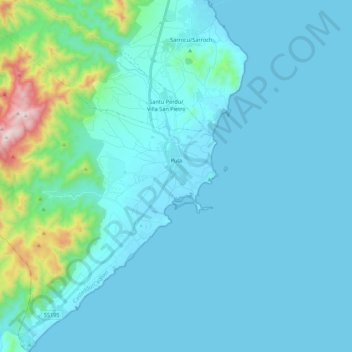
Name: Pula topographic map, elevation, terrain.
Location: Pula, Cagliari, Sardegna, 09010, Italia (38.91547 8.83193 39.08446 9.03320)
Average elevation: 89 m
Minimum elevation: -2 m
Maximum elevation: 845 m
Other topographic maps
Click on a map to view its topography, its elevation and its terrain.
Punta Sebera
Punta Sebera, Pula, Cagliari, Sardegna, 09010, Italia
Average elevation: 813 m