
Thank you for supporting this site ❤️
Make a donation
Make a donation
Shkhara topographic map
Click on the map to display elevation.
Thank you for supporting this site ❤️
Make a donation
Make a donation
About this map
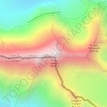
Name: Shkhara topographic map, elevation, terrain.
Average elevation: 4,355 m
Minimum elevation: 3,504 m
Maximum elevation: 5,224 m
Thank you for supporting this site ❤️
Make a donation
Make a donation
Other topographic maps
Click on a map to view its topography, its elevation and its terrain.
Central Caucasian Ridge
Russia > Kabardino-Balkaria > Cherek District > Verkhnyaya Balkariya
The highest and rockiest section of the range is located in its central part. Although not as high as the topmost summits of the Lateral Range to the north, the highest elevations of the Main Caucasian Range include the 5,193 meters (17,037 ft) high Shkhara, the 4,466 meters (14,652 ft) high Mount Bazardüzü…
Average elevation: 2,784 m