
West Pomeranian Voivodeship topographic map
Interactive map
Click on the map to display elevation.
About this map
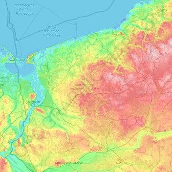
Name: West Pomeranian Voivodeship topographic map, elevation, terrain.
Location: West Pomeranian Voivodeship, Poland (52.62433 14.12297 54.56991 16.98208)
Average elevation: 58 m
Minimum elevation: -6 m
Maximum elevation: 231 m
Other topographic maps
Click on a map to view its topography, its elevation and its terrain.
Police
Poland > West Pomeranian Voivodeship > Police
Police, gmina Police, powiat policki, West Pomeranian Voivodeship, Poland
Average elevation: 6 m