
Improvement District No. 9 topographic map
Interactive map
Click on the map to display elevation.
About this map
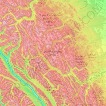
Name: Improvement District No. 9 topographic map, elevation, terrain.
Location: Improvement District No. 9, Alberta, Canada (50.70506 -117.31712 52.27145 -115.16491)
Average elevation: 1,848 m
Minimum elevation: 773 m
Maximum elevation: 3,472 m
Other topographic maps
Click on a map to view its topography, its elevation and its terrain.
Banff
Canada > Alberta > Banff > Banff
Banff is a town within Banff National Park in Alberta, Canada. It is located in Alberta's Rockies along the Trans-Canada Highway, approximately 126 km (78 mi) west of Calgary and 58 km (36 mi) east of Lake Louise. At 1,400 to 1,630 m (4,590 to 5,350 ft) above sea level, Banff is the community with the second…
Average elevation: 1,615 m
Lake Louise
Canada > Alberta > Improvement District No. 9
Lake Louise is a hamlet within Banff National Park in Alberta, Canada. Named after Princess Louise, Duchess of Argyll, it lies in Alberta's Rockies on the Bow River, 3 km (1.9 mi) northeast of the lake that shares its name. Initially settled in 1884 as an outpost for the Canadian Pacific Railway, Lake Louise…
Average elevation: 1,617 m
Nose Hill Park
Names currently associated with topographical features in and near Nose Hill Park reflect the impact of the European newcomers and European trade goods on the Peigan. For example, Spy Hill, the westward extension of Nose Hill, derived its present name from the aboriginal practice of communicating with distant…
Average elevation: 1,174 m
Canmore
Canada > Alberta > Town of Canmore
Elevation Place opened in April 2013 as Canmore's new recreation facility. Construction of the facility began in 2012 to replace the Canmore Recreation Centre (the community's old facility). The facility offers an 8-lane 25m lap pool, a world class climbing wall developed by Walltopia, two cardio rooms, a…
Average elevation: 1,565 m
Grande Prairie
Canada > Alberta > Grande Prairie
Grande Prairie is located just north of the 55th parallel north, and is 465 km (289 mi) northwest of Edmonton, lying at an elevation of 669 m (2,195 ft) above sea level. The city is surrounded by farmland to the north, east, and west. To the south lies a vast boreal forest with aspen, tamarack, lodgepole pine,…
Average elevation: 668 m
Lethbridge
Canada > Alberta > Lethbridge
Its high elevation of 929 m (3,047.9 ft) and close proximity to the Rocky Mountains provides Lethbridge with cooler summers than other locations in the Canadian Prairies. These factors protect the city from strong northwest and southwest winds and contribute to frequent chinook winds during the winter.…
Average elevation: 918 m
Cochrane
Canada > Alberta > Town of Cochrane > Cochrane
Cochrane is situated at the base of Big Hill in the Bow River Valley. It sits at an elevation of 1,186 m (3,891 ft). The town is intersected by Highway 1A and Highway 22. Cochrane has a reputation for its western culture, which can easily be felt when one wanders the streets (particularly Main Street). The…
Average elevation: 1,205 m
Waterton Park
Canada > Alberta > Improvement District No. 04
It is located at the southwestern terminus of Highway 5, approximately 54 kilometres (34 mi) west of the Town of Cardston and 55 kilometres (34 mi) south of the Town of Pincher Creek. This hamlet is north of Glacier National Park in Montana. It has an elevation of 1,280 metres (4,200 ft).
Average elevation: 1,456 m
Tunnel Mountain
Canada > Alberta > Improvement District No. 9
Although only 5500 feet in altitude above sea level, the summit is a magnificent viewpoint, covering the Bow River valley both east and west. The chief advantage is that, set at a position ... midway between the valley bottom and the crests of the encircling mountain ranges, it does full value in perspective…
Average elevation: 1,423 m
Snow Dome
Canada > Alberta > Improvement District No. 12 > Area A (Kicking Horse/Kinbasket Lake)
Average elevation: 3,226 m
Red Earth Creek
Canada > Alberta > Municipal District of Opportunity
Red Earth Creek is a hamlet in Alberta, Canada within the Municipal District of Opportunity No. 17. It is located east of Highway 88, between the town of Slave Lake and the hamlet of Fort Vermilion, and has an elevation of 520 metres (1,710 ft).
Average elevation: 549 m
Maligne Canyon
Canada > Alberta > Municipality of Jasper
While visually striking and unusual, slot canyons are a common occurrence within the northern Rocky Mountains. These canyons show the characteristics of karst topography and are common in this region due to the easily soluble nature of the limestone. Flowing out of Medicine Lake, the Maligne River flows about…
Average elevation: 1,134 m
Nisku
Canada > Alberta > Leduc County
Nisku is a hamlet and an industrial/business park in Alberta, Canada, within Leduc County. It has an elevation of 705 metres (2,313 ft).
Average elevation: 714 m
Kingman
Canada > Alberta > Camrose County
Kingman is a hamlet in central Alberta, Canada within Camrose County. It is located approximately 27 kilometres (17 mi) north of Camrose and has an elevation of 740 metres (2,430 ft).
Average elevation: 747 m
Nordegg
Canada > Alberta > Clearwater County
Nordegg has a subarctic climate (Dfc) which can be considered a subalpine climate due to its altitude with locations on the same latitude having warmer climates. Summers are mild, with a few warm days sprinkled in here and there, while winters are cold and snowy.
Average elevation: 1,399 m
Livingstone Range
Canada > Alberta > Municipal District of Ranchland No. 66
Average elevation: 1,825 m
Mount Rundle
Canada > Alberta > Improvement District No. 9
In Banff, the Spray River trailhead for the first peak taking the Mount Rundle Trail, is near the Spray River bridge on the road to the Banff Springs Golf Course. The all-day hike (from 8–10 hours) from the trailhead to the peak is about 5 kilometres (3.1 mi) one-way and has an elevation gain of about 993…
Average elevation: 2,353 m
Viewpoint North Saskatchwan River
Canada > Alberta > Improvement District No. 9
Average elevation: 1,432 m
Lake Louise
Canada > Alberta > Improvement District No. 9
Lake Louise is a hamlet within Banff National Park in Alberta, Canada. Named after Princess Louise, Duchess of Argyll, it lies in Alberta's Rockies on the Bow River, 3 km (1.9 mi) northeast of the lake that shares its name. Initially settled in 1884 as an outpost for the Canadian Pacific Railway, Lake Louise…
Average elevation: 1,617 m