
Franklin topographic map
Interactive map
Click on the map to display elevation.
About this map
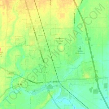
Name: Franklin topographic map, elevation, terrain.
Location: Franklin, Johnson County, Indiana, 46131, United States (39.45993 -86.09377 39.54228 -86.00277)
Average elevation: 230 m
Minimum elevation: 214 m
Maximum elevation: 250 m
Other topographic maps
Click on a map to view its topography, its elevation and its terrain.
Nineveh
United States > Indiana > Johnson County
Nineveh, Johnson County, Indiana, United States
Average elevation: 238 m
Trafalgar
United States > Indiana > Johnson County
Trafalgar, Johnson County, Indiana, United States
Average elevation: 257 m
Greenwood
United States > Indiana > Johnson County
Greenwood, Johnson County, Indiana, United States
Average elevation: 245 m
Bargersville
United States > Indiana > Johnson County
Bargersville, Johnson County, Indiana, 46106, United States
Average elevation: 243 m
Edinburgh
United States > Indiana > Johnson County
Edinburgh, Johnson County, Indiana, United States
Average elevation: 205 m
Stones Crossing
United States > Indiana > Johnson County > Greenwood
Stones Crossing, Greenwood, Johnson County, Indiana, 46143, United States
Average elevation: 238 m
Green Valley
United States > Indiana > Johnson County > Greenwood
Green Valley, Greenwood, Johnson County, Indiana, 46143, United States
Average elevation: 239 m