
Thank you for supporting this site ❤️
Make a donation
Make a donation
Saint-Cassien-des-Caps topographic map
Click on the map to display elevation.
Thank you for supporting this site ❤️
Make a donation
Make a donation
About this map
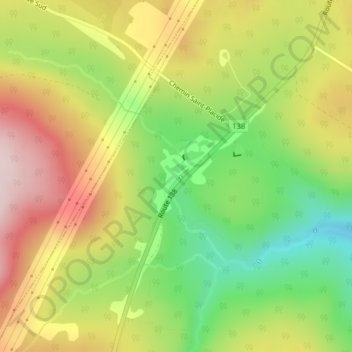
Name: Saint-Cassien-des-Caps topographic map, elevation, terrain.
Average elevation: 435 m
Minimum elevation: 271 m
Maximum elevation: 606 m
Thank you for supporting this site ❤️
Make a donation
Make a donation
Other topographic maps
Click on a map to view its topography, its elevation and its terrain.
Petite rivière Saint-François
Canada > Québec > Charlevoix > Petite-Rivière-Saint-François
Average elevation: 436 m