
Sâmbăta topographic map
Interactive map
Click on the map to display elevation.
About this map
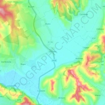
Name: Sâmbăta topographic map, elevation, terrain.
Location: Sâmbăta, Bihor, Romania (46.76225 22.15756 46.83897 22.25597)
Average elevation: 171 m
Minimum elevation: 129 m
Maximum elevation: 280 m
Other topographic maps
Click on a map to view its topography, its elevation and its terrain.
Huta Voivozi
Romania > Bihor > Huta Voivozi
Huta Voivozi, Șinteu, Bihor, 417551, Romania
Average elevation: 589 m
Parcul Salca
Parcul Salca, Dimitrie Cantemir, Oradea, Oradea Metropolitan Area, Bihor, Romania
Average elevation: 133 m