
Banner Elk topographic map
Interactive map
Click on the map to display elevation.
About this map
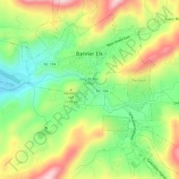
Name: Banner Elk topographic map, elevation, terrain.
Location: Banner Elk, Avery County, North Carolina, United States (36.13897 -81.88774 36.17356 -81.84810)
Average elevation: 1,165 m
Minimum elevation: 1,036 m
Maximum elevation: 1,332 m
Banner Elk is located in North America's humid continental climate zone due to its elevation, which gives it a climate more like that of Altoona, Pennsylvania, than Asheville, North Carolina, during the winter. During the summer the temperatures are much like a mountain lake town in New Hampshire. The town typically has cold, snowy winters and mild summers.
Other topographic maps
Click on a map to view its topography, its elevation and its terrain.
Mount Gilead
United States > North Carolina > Avery County
Mount Gilead, Avery County, North Carolina, United States
Average elevation: 891 m
Beech Mountain
United States > North Carolina > Avery County > Beech Mountain
Beech Mountain, Avery County, North Carolina, 28604, United States
Average elevation: 1,433 m
Newland
United States > North Carolina > Avery County
Newland, Avery County, North Carolina, United States
Average elevation: 1,140 m
Sugar Mountain
United States > North Carolina > Avery County > Sugar Mountain
Sugar Mountain, Avery County, North Carolina, United States
Average elevation: 1,385 m