
Thank you for supporting this site ❤️
Make a donation
Make a donation
Montarmot topographic map
Click on the map to display elevation.
Thank you for supporting this site ❤️
Make a donation
Make a donation
About this map
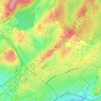
Name: Montarmot topographic map, elevation, terrain.
Average elevation: 329 m
Minimum elevation: 262 m
Maximum elevation: 397 m
Thank you for supporting this site ❤️
Make a donation
Make a donation
Other topographic maps
Click on a map to view its topography, its elevation and its terrain.
Thank you for supporting this site ❤️
Make a donation
Make a donation
Fort de Planoise
France > Bourgogne-Franche-Comté > Doubs > Besançon > Aux Valières
Average elevation: 298 m