
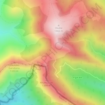
Orgarate topographic map
Interactive map
Click on the map to display elevation.
About this map
Name: Orgarate topographic map, elevation, terrain.
Average elevation: 1,205 m
Minimum elevation: 889 m
Maximum elevation: 1,463 m
Other topographic maps
Click on a map to view its topography, its elevation and its terrain.
Irau
France > Nouvelle-Aquitaine > Lecumberry
Irau, Ezterenzubi - Irati-Garazi errepidea, Intzarazkiko Etxolak, Lecumberry, Bayonne, Pyrénées-Atlantiques, Nouvelle-Aquitaine, France métropolitaine, 64220, France
Average elevation: 950 m
Urkulu
France > Nouvelle-Aquitaine > Lecumberry
Urkulu, Lecumberry, Bayonne, Pyrénées-Atlantiques, Nouvelle-Aquitaine, France métropolitaine, 64220, France
Average elevation: 991 m
Cromlech d'Okabé
France > Nouvelle-Aquitaine > Lecumberry
Cromlech d'Okabé, Chemin de Curutchecolephoua à Sourçay, Gaznatei, Lecumberry, Bayonne, Pyrénées-Atlantiques, Nouvelle-Aquitaine, France métropolitaine, 64220, France
Average elevation: 1,187 m